Fish.Dive.Explore.

Australia's coast and inland waterways, reduced to one clear answer: where to go, what to target and how to fish it. Reefseeker combines thousands of established fishing marks, deep species knowledge, mapped seabed and live conditions, so you spend less time guessing and more time on the water.

Free while we test. Works in your browser; add it to your home screen to install.
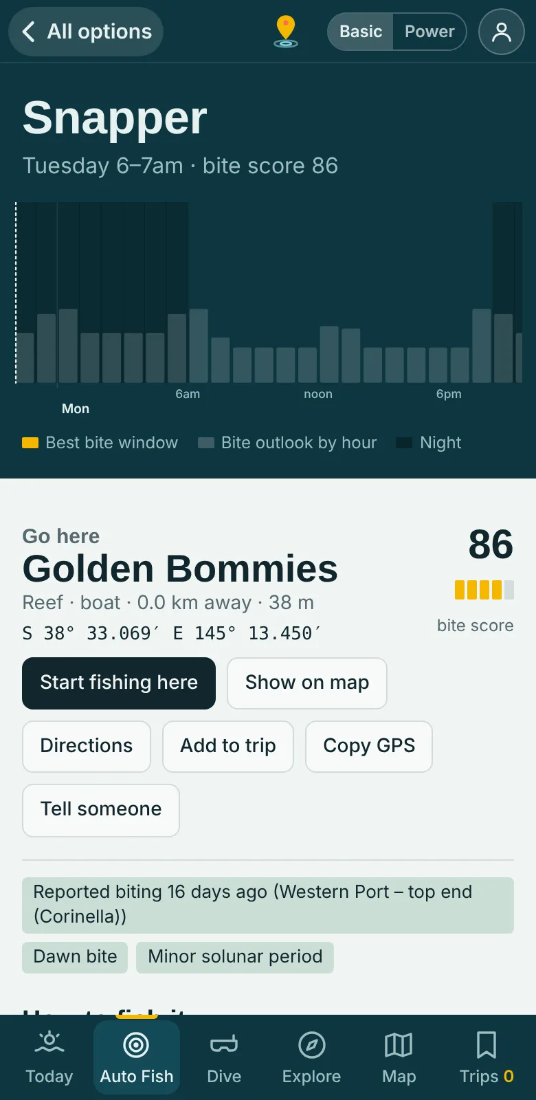
The Reefseeker Auto Fish screen: a snapper plan with the bite-time chart, the suggested mark, distance, depth and bite score
6,300+established fishing & dive marks
900,000+km² of surveyed, mapped seabed
160species profiles
95+report sources scanned
The data set

An enormous database of where fish are actually caught

Every suggestion starts with ground truth: thousands of established fishing locations with known catch records, gathered from across Australia and tied to species, season, tide, bottom type and technique. Our own research on how each species behaves and how it is fished is layered on top, so the app reasons about places instead of just showing pins.

πŸ“

6,300+ established marks

Reefs, wrecks, jetties, rock platforms, drop-offs, channels, rivers, lakes and dams across every state and territory, each with its known catches and the conditions it fishes best in.

🐟

160 species profiles

Behaviour, preferred water temperature, light, tide, depth and bottom type, plus the rigs, baits, lures and techniques that work, with location-specific research.

🧭

Dive, snorkel & explore

700+ places: entry points, depths and skill levels for dives, plus lookouts, shipwrecks, lighthouses, wildlife watching and swimming holes, with safety checks built in.

πŸ›‘οΈ

Marine park & no-take zones

Thousands of zone boundaries so the coach never sends you into a sanctuary area, plus rules for every jurisdiction.

πŸ—ΊοΈ

Mapped seabed

National seabed habitat and depth mapping covering around 900,000 km² of surveyed Australian seabed feeds every calculation, so the app knows reef from sand from weed under the boat.

πŸŽ›οΈ

Sounder setup guidance

Starting settings for your fish finder, using the menu names of Garmin, Humminbird, Lowrance, Simrad, Raymarine and Furuno units.
Fish finder help

Your sounder, set up for the spot you are fishing

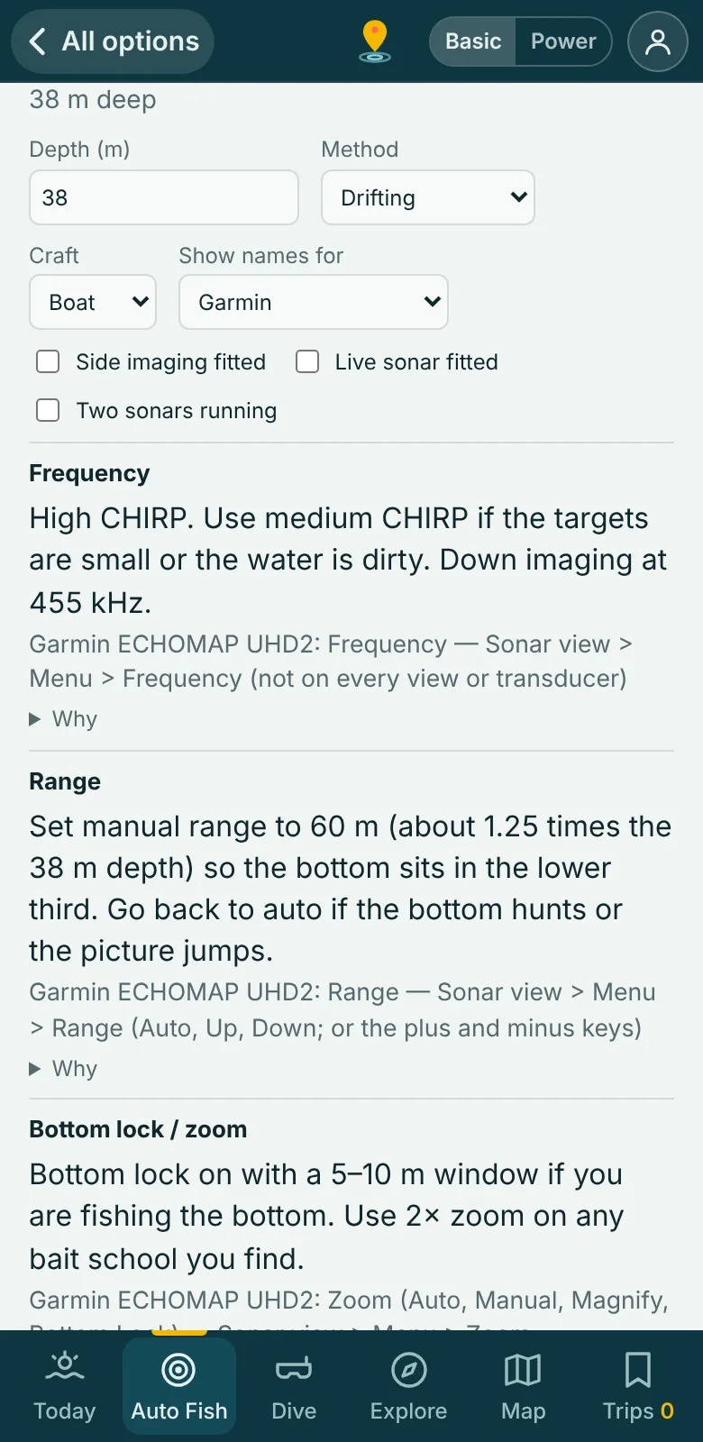
Tell Reefseeker what you run and it gives you starting settings for the depth, bottom and conditions at your mark: frequency, range, bottom lock, gain, surface clarity, noise rejection and more, each with a plain-English reason.

  • Menu names and locations for Garmin, Humminbird, Lowrance, Simrad, Raymarine and Furuno, checked against the makers' manuals, with model-specific menus where they differ
  • Reads the seabed under you, so you know what rock, sand, weed or mud looks like on your screen
  • Adjusts for boat, kayak or jet ski, side imaging, live sonar and two-sonar set-ups
  • On the water, one tap from the fishing screen, and tell us when it is dialled in or still noisy
The Reefseeker sounder setup card showing frequency and range advice with Garmin menu names
Live data streams

The ocean changes by the hour. So does Reefseeker.

The coach re-reads conditions as they change and tells you what to do next. Live catch reports are only one small part of it; these feeds work behind every suggestion.

🌬️

Wind & weather

Hour-by-hour forecasts with safety warnings when conditions turn.

Live
🌊

Swell, waves & tide

Marine forecasts, swell and tide phase shape the bite windows and which marks are safe.

Live
🌑️

Sea temperature & breaks

Sea-surface temperature, and the temperature edges where baitfish and predators stack up.

Daily
πŸ“°

Live catch reports

We constantly scan close to a hundred data sources for facts about real catches, and deliver them to you live.

Live
πŸ‘₯

Angler signals

Opt-in results from other Reefseeker anglers, shared as anonymous results in a rough area, boost spots that are firing.

Live
πŸ—ΊοΈ

Seabed & depth

Official depth contours, seabed habitat and survey coverage from Seamap Australia and Geoscience Australia, around 900,000 km² of surveyed seabed.

On demand
The intelligence

From mountains of data to one simple instruction

You shouldn't need to read ten charts. Reefseeker works out the best location, species and fishing method for you, right now.

1. Know

  • An enormous database of established fishing locations with known catch records
  • Species behaviour, seasons and habits
  • Techniques, rigs and location-specific research
  • Mapped seabed, depth and zoning
➜

2. Weigh live conditions

  • Weather, wind, swell and tide, hour by hour
  • Sea temperature and temperature breaks
  • Fresh catch reports and angler signals
  • Is it legal and safe to be there?
➜

3. Coach

A clear move: where to go, what to target and how to fish it, with sounder settings to match. It adapts as your session goes and learns from your catches.

Two ways to use it

Simple when you want it. Everything when you need it.

Switch any time from the top of the app.

Basic

A clean display on your phone. The app does the hard work in the background and gives you easy guidance.

  • Uncluttered map
  • One clear suggestion at a time
  • Boat ramps and depth at a tap

Power fish

For the keen angler on a tablet or PC: see the actual data and draw your own conclusions.

  • Depth contours, seabed habitat and survey layers
  • Full filters and access types
  • Live "right now" conditions and reports
Built to be trusted

Honest about what it knows

Safety first

No-take zones are filtered out, and weather and swell warnings are shown before you go. Reefseeker is a guide, not a navigation aid: always check official sources.

Fair to sources

We only use facts from public pages, write our own summaries, link back to the source and obey robots.txt. About ReefseekerBot.

Your privacy

Sharing catches is opt-in and anonymous: just species, result, an approximate area and the hour. Read the policy.

Early access
Free
while we test
  • Every region, mark and live feed
  • Basic and Power modes
  • Coach, reports and trip planning

Open Reefseeker
Paid plans will arrive later. Early testers will hear first.

Questions

Where does Reefseeker work?

All Australian states and territories: the coast and offshore reefs, estuaries, rivers, lakes and dams, with the deepest coverage along the east, south and west coasts.

Do I need to install anything?

No. It runs in your browser. Add it to your home screen for an app-like experience.

Does it work without signal?

The marks and zoning load with the app, but live weather, tide, satellite and report feeds need a connection. Fetch before you leave the ramp.

Can I trust the depth and marks?

Treat them as guidance. Many positions are estimated from written descriptions and seabed data is gridded, so always use a chart plotter and proper navigation, and keep a lookout.

What will it cost?

Nothing while we test. When paid plans arrive, the essentials will stay simple and early testers will be told first.